MSU scientists presented a large-scale NERM database tracking changes in the coastline of rivers in Northern Eurasia. This unique tool will help predict risks to infrastructure and assess the resilience of river systems in the face of climate change.
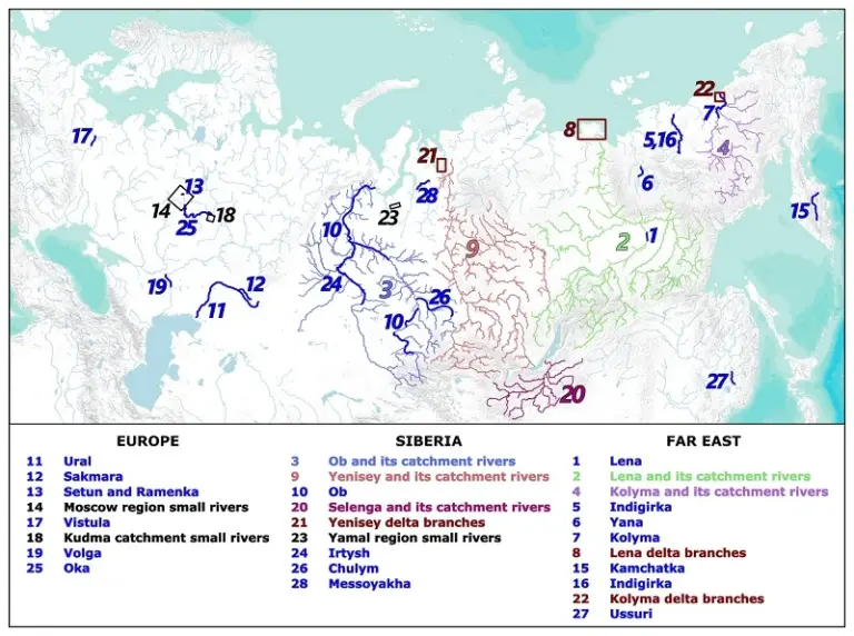
Geographers of the Moscow State university Together with an international team of researchers, we completed the creation of a comprehensive NERM database covering more than 620 thousand river bank sites. The total length of the explored channels exceeds 140 thousand kilometers, which makes the base the largest open resource of its kind in the world.
The database includes data on the largest river systems in the region: the Volga, Ob, Yenisei, Lena, Amur and many other waterways. Particular attention is paid to small rivers of the Moscow region and other significant watercourses.
To form the database, scientists used an integrated approach, combining field measurements with analysis of Landsat and Sentinel satellite images, as well as aerial photography from drones. This multi-level analysis made it possible to obtain accurate estimates of the rate of change of the coastline, the volume of soil erosion and other key parameters.
Professor of the Faculty of Geography of Moscow State University Sergei Chalov, project leader, emphasizes: “Our research has revealed clear geographical patterns. In the Arctic regions, thermal abrasion processes associated with the thawing of permafrost predominate, while in temperate latitudes hydrodynamic mechanisms dominate.”
The database is already available for practical use in two formats: an interactive map with visualization of changes by year and a data archive in the repository Zenodo. This opens up broad opportunities for scientific organizations, designers and natural risk assessors.
The creation of NERM was carried out within the framework of the Megagrant of the Government of the Russian Federation, dedicated to the study of river basins. The large-scale project forms the basis for the development of predictive models and the creation of a unified system for monitoring river dynamics throughout Eurasia.
The material was prepared with the support of the Russian Ministry of Education and Science as part of the Decade of Science and Technology.
Source: geogr.msu.ru
Photo: Ob River, author A. Zavadsky