chatgpt image 16 авг. 2025 г., 16 56 08

Ground penetrating radar and depth of 1000 meters: myth or reality

13.01.2025
Reading time: 4 min
0

Sometimes you can hear loud advertising promises: “Our georadar sees to a depth of 1000 meters.” It sounds impressive, and many are ready to believe it. But how true is this? Let’s figure out how the method works, where it is effective and where the figure of a thousand meters comes from.

How does the GPR method work?

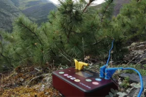
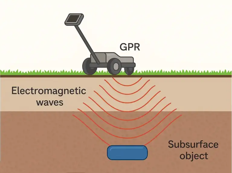
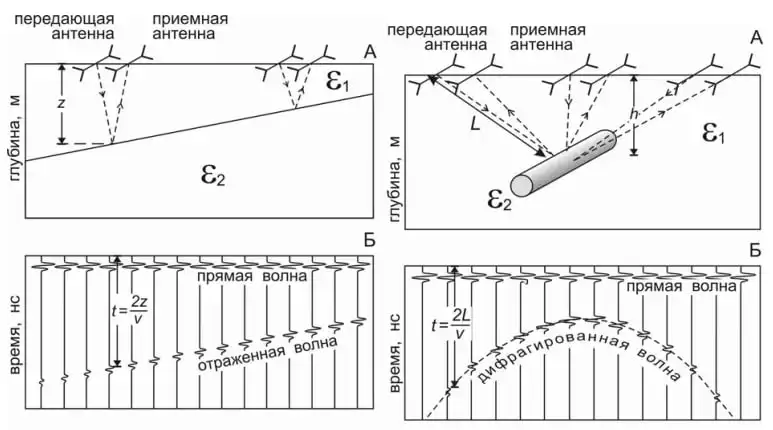
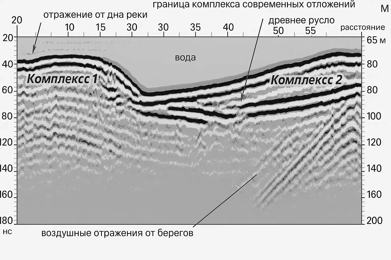
The method is based on the emission of electromagnetic pulses and registration of signals reflected from the boundaries of layers with different electrical properties. This allows you to record:

  • groundwater level (contact of dry and moisture-saturated rocks),
  • the boundary between thawed and frozen rocks,
  • transition of loose sediments to bedrock,
  • underground communications – pipelines and cables.

If the soils have high resistance, and the operating frequency of the georadar is tens of megahertz, the electromagnetic wave behaves like an elastic wave: it is reflected, refracted and diffracted according to the laws of geometric optics. For example, with resistances of 150–300 Ohm m and a frequency of 50–100 MHz, the research depth will be only 10–15 meters. In the presence of clays, silts and loams, the depth is even less.

The principle of operation of ground penetrating radar: reflection and diffraction of electromagnetic waves when meeting the boundary of layers and underground objects
Scheme of GPR operation: signal reflection from an inclined layer boundary (left) and diffraction from a pipe (right). The depth section is shown at the top, the time records are shown at the bottom. Source: manual on electrical prospecting practice for students of geophysical specialties

Problems that the method solves

Today, GPR is used in many areas:

  • engineering surveys and construction projects,
  • archeology and burial search,
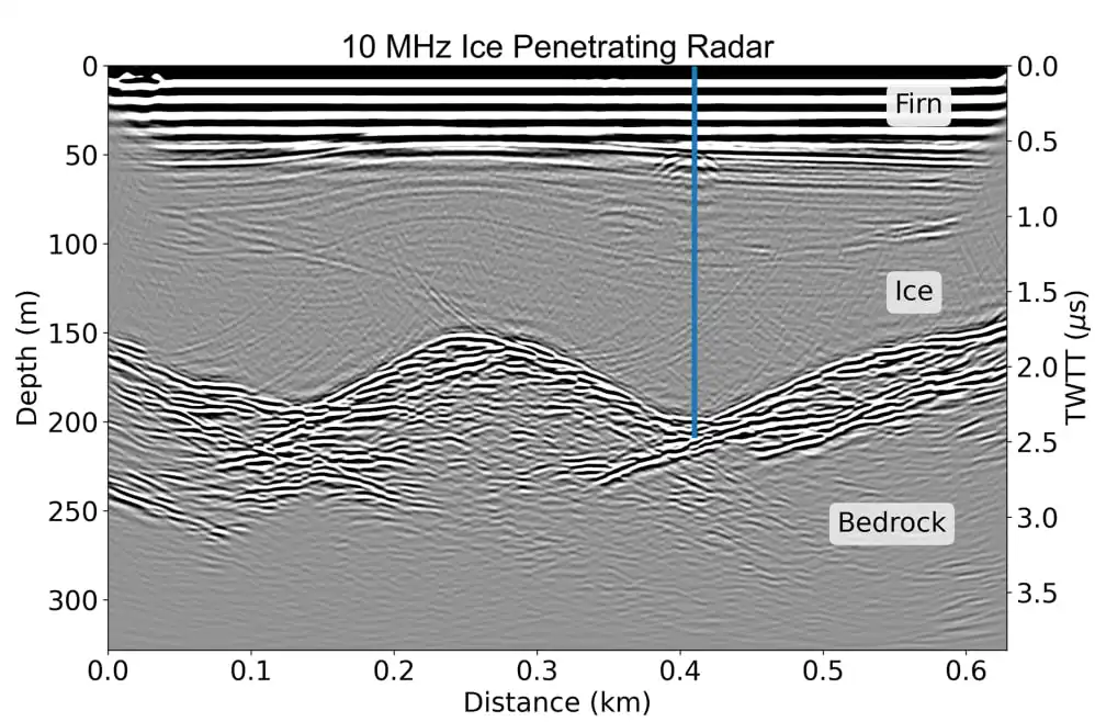
  • study of permafrost and glaciers,
  • mapping of underground communications,
  • geological studies of the upper layers of soil.

On most rocks, the actual depth of exploration is from several meters to tens of meters.

GPR section through the bed of the Ugra River highlighting complexes of sediments and the ancient riverbed
GPR results on the river. Ugra: field recording, processing and interpretation of data. Source: manual on electrical prospecting practice for students of geophysical specialties

Where did the number “1000 meters” come from?

There are indeed results in the scientific literature where the ground penetrating radar “penetrated” up to a kilometer. But such data relate to glacier studies. Ice is practically transparent to radio waves, and therefore the signal can travel great distances without much attenuation. But this is an exception, and not a universal characteristic of the method.

GPR cross-section through a glacier highlighting firn, ice and bedrock
10 MHz GPR profile on the Beggouia Plateau (2022). The vertical blue line shows the location of the Denali ice core (DEN-13B). Source article Early Holocene ice on the Begguya plateau (Mt. Hunter, Alaska) revealed by ice core 14C age constraints

Where to be careful

If you are offered a “kilometer-long ground penetrating radar” to search for ore bodies or deep structures in hard rocks, this is manipulation. In practice, the method is limited to tens of meters. For deep problems, other methods are needed: seismic prospecting, electrical prospecting, magnetotellurics.

Ground penetrating radar is an important tool for the geologist and engineer. But like any method, it has limitations. In soils and rocks it is tens of meters. In glaciers – up to a kilometer. Therefore, when you hear promises of “ground penetrating radar up to 1000 m”, it is important to clarify: where exactly and under what conditions.

Have you encountered inflated promises in geophysics? Share your experience in the comments.

Prepared by —
Аватарка автора
Maria Kostina
Tags
Liked the news? Share it with friends
Related

Leave your comment


Editor-in-Chief
Maria Kostina
Maria Kostina
Geophysicist, founder of the project and editor-in-chief GeoConversation. Salt of the Earth
GO TO THE EDITOR'S COLUMN

GeoConversation. Salt of the Earth is a media platform where top mining-industry specialists share their experience, helping professionals communicate and collaborate more effectively.

Learn more about the project
TOP PROFESSIONALS
Исхак Фархутдинов

Iskhak Farhutdinov

V.I. Vernadsky State Geological Museum of the Russian Academy of Sciences
Academic Secretary
4

Alina Pavlovskaya

Gold Deposit Development
Chief Geologist, placer gold expert
Александр Чеботарев — ведущий геолог, эксперт в геонавигации и сопровождении бурения. Более 5 лет опыта в нефтегазовой отрасли.

Alexander Chebotarev

Surgutneftegas
Lead Geologist
VIEW ALL EXPERTS
CATEGORIES
SUBSCRIBE
If you would like to receive a monthly selection of fresh articles by email
LIKE THE PROJECT? SUPPORT US
Friends, developing the project takes a lot of effort and financial resources. If you like what we do, you can support us in two ways.
MORAL SUPPORT
Show our website to your friends. Just click on the social media icons below and share our website on your pages.
FINANCIAL SUPPORT
Even a small fee will help us pay for the transcription (audio to text) of an expert interview or the design of drawings, diagrams, and tables.
Send a donation
Got an article idea? Suggest it.
Cool! You have an idea for us. We love that, because only the experience and knowledge of an expert makes our articles useful for the reader. Please answer 5 questions to let us know a little more about you and the article
answer questions