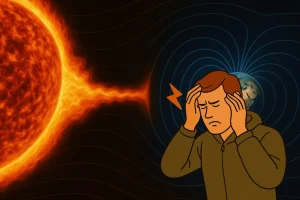
Artificial intelligence is everywhere now. ChatGPT, neural networks for images, automation of everything. It seems that AI has already penetrated all spheres, but in reality, machine learning has been applied in our industry for a long time—it just wasn’t as noticeable or popular before. The boom in generative neural networks made the topic trendy and “hyped,” but beyond the noise, AI has been helping geophysicists work with data for several years. This includes one of the most labor-intensive tasks: interpreting seismic cubes.
To understand exactly how it works, what data models are trained on, and whether they can be trusted, we spoke with Daniil Bogoedov, Head of Artificial Intelligence Research and Development at GridPoint Dynamics (Geoplat software).

What is Artificial Intelligence in Geophysics?
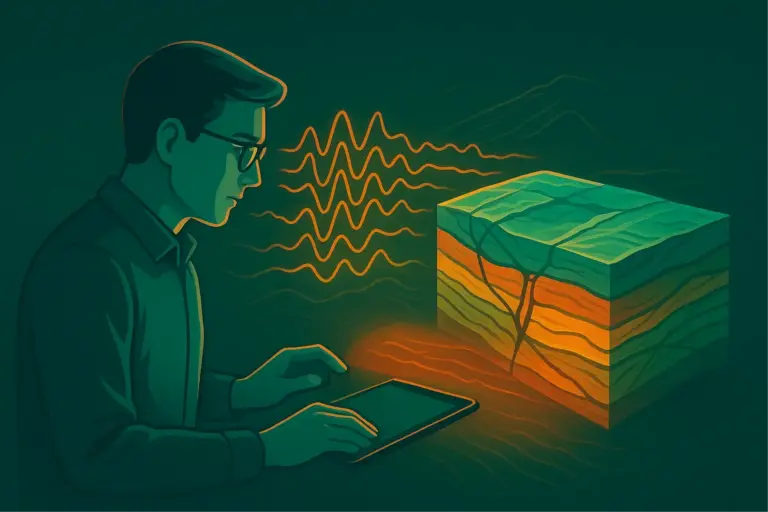
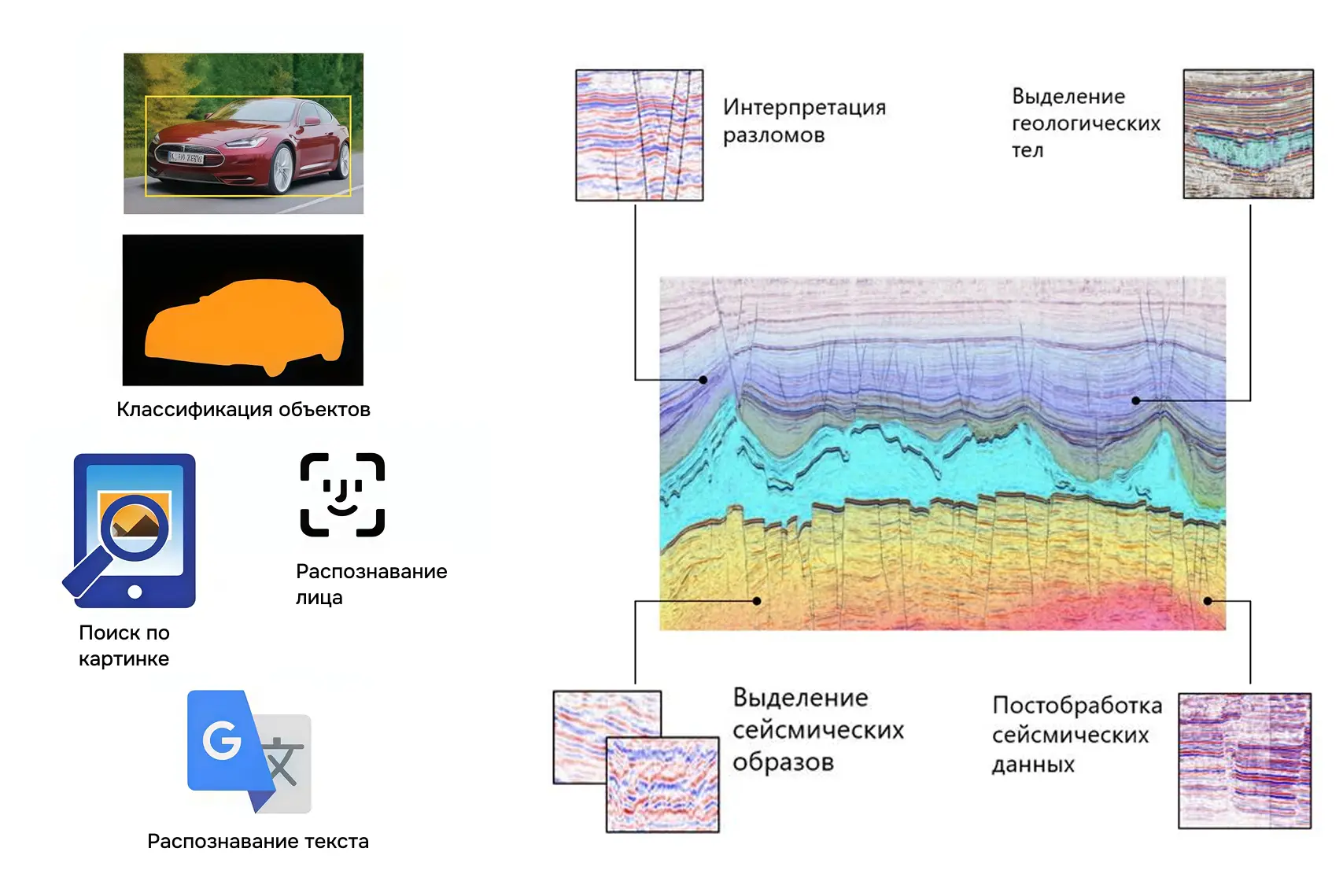
In geophysics, artificial intelligence works on the same principle as in other fields—it recognizes patterns. Only in our case, these are not photographs or texts, but seismic data. Algorithms identify patterns in cubes and automatically highlight geological structures: horizons, faults, paleochannels, reefs, etc. Essentially, this is the same “object recognition” logic, but transferred to the language of geology.
If you’re interested in learning more about the types of neural networks, how convolutional models work, and how artificial intelligence differs from machine learning, read our separate article—everything is explained in detail with examples: “How Artificial Intelligence Makes Mining Smarter”.
Now, let’s look at how these approaches work specifically in seismic data interpretation. Previously, specialists spent months manually correlating horizons and faults. But with the advent of artificial intelligence-based tools, the process has changed.
How AI Recognizes Faults and Paleo-structures
Before discussing how work is changing with the advent of AI, it is important to clarify: processing and interpretation are different stages.
- Processing is performed on specialized high-performance systems, often under Linux, and can involve terabytes of information.
- Interpretation is already working with ready-made seismic cubes ranging from several to hundreds of gigabytes. These can be worked with on local machines under Windows and Linux: viewing images, correlating horizons and faults, performing dynamic analysis.
How does a geophysicist-interpreter typically work? They spend months at their desk, manually drawing horizon lines, outlining faults, and checking each section. Even a simple project can take six months, and a complex one even longer. This is still how most specialists work.
Now, consider a different scenario with artificial intelligence. First, a basic pre-trained model is calculated, and the geologist immediately identifies fault probabilities. Next, there is an option to fine-tune the model using labeled sections and Transfer Learning technology to incorporate their interpretation vision into the model. What used to take months is now completed in weeks, and sometimes even hours. For example, well tie-in to seismic, which previously took about 90 minutes, is now done in 2 minutes. How is this possible? Let’s explore further.
How AI Recognizes Faults and Paleo-structures
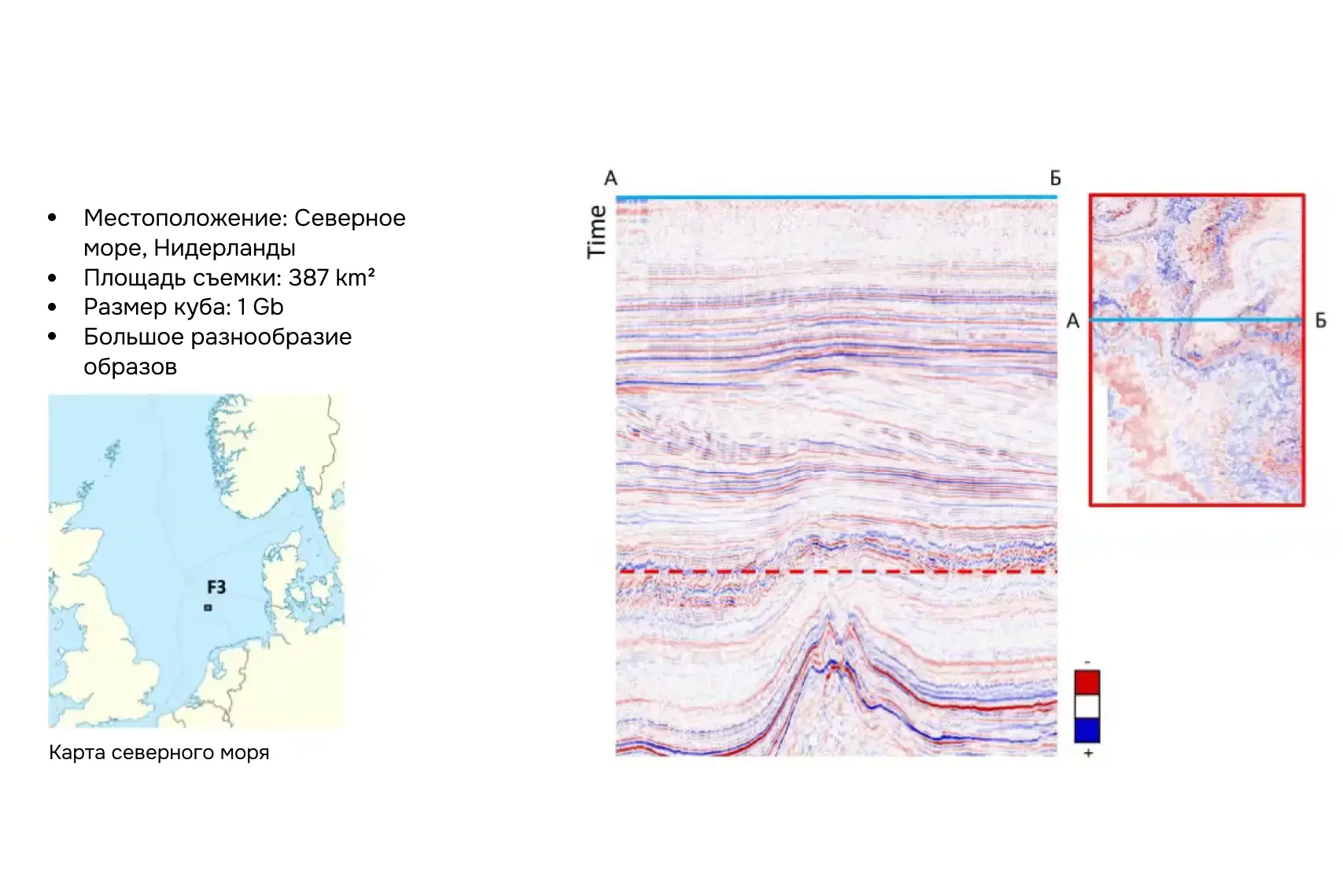
To understand exactly how artificial intelligence works in interpretation, let’s consider a specific case. As a test site, we will take North Sea data – one of the most famous test projects, combining complex salt structures, chaotic reflections, and calmer layers higher in the section. This diversity makes it convenient for testing technologies. The interpretation here was performed on the Geoplat platform.
This section is based on the webinar “Volumetric Classification of Seismic Patterns Using Deep Machine Learning” by GridPoint Dynamics (Geoplat software).
Step 1: Load the Cube
We load a seismic cube onto the screen and review the inlines and crosslines to assess the diversity of reflections. Salt domes with low-frequency signals are clearly visible at the bottom, while complexes with consistent reflections and a higher frequency spectrum are visible above.
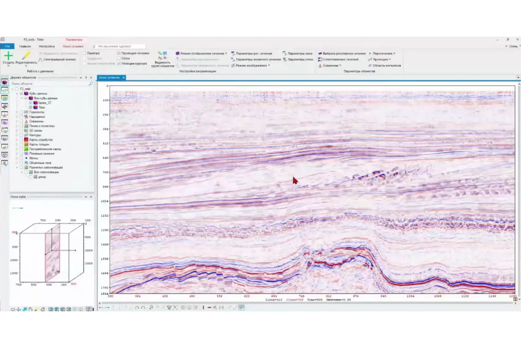
Step 2: Analyze Primary Data
We select a tool for structural search. The algorithm automatically highlights baselines, identifies zones of potential faults, and facies boundaries. This is a rough interpretation, which the specialist then refines.
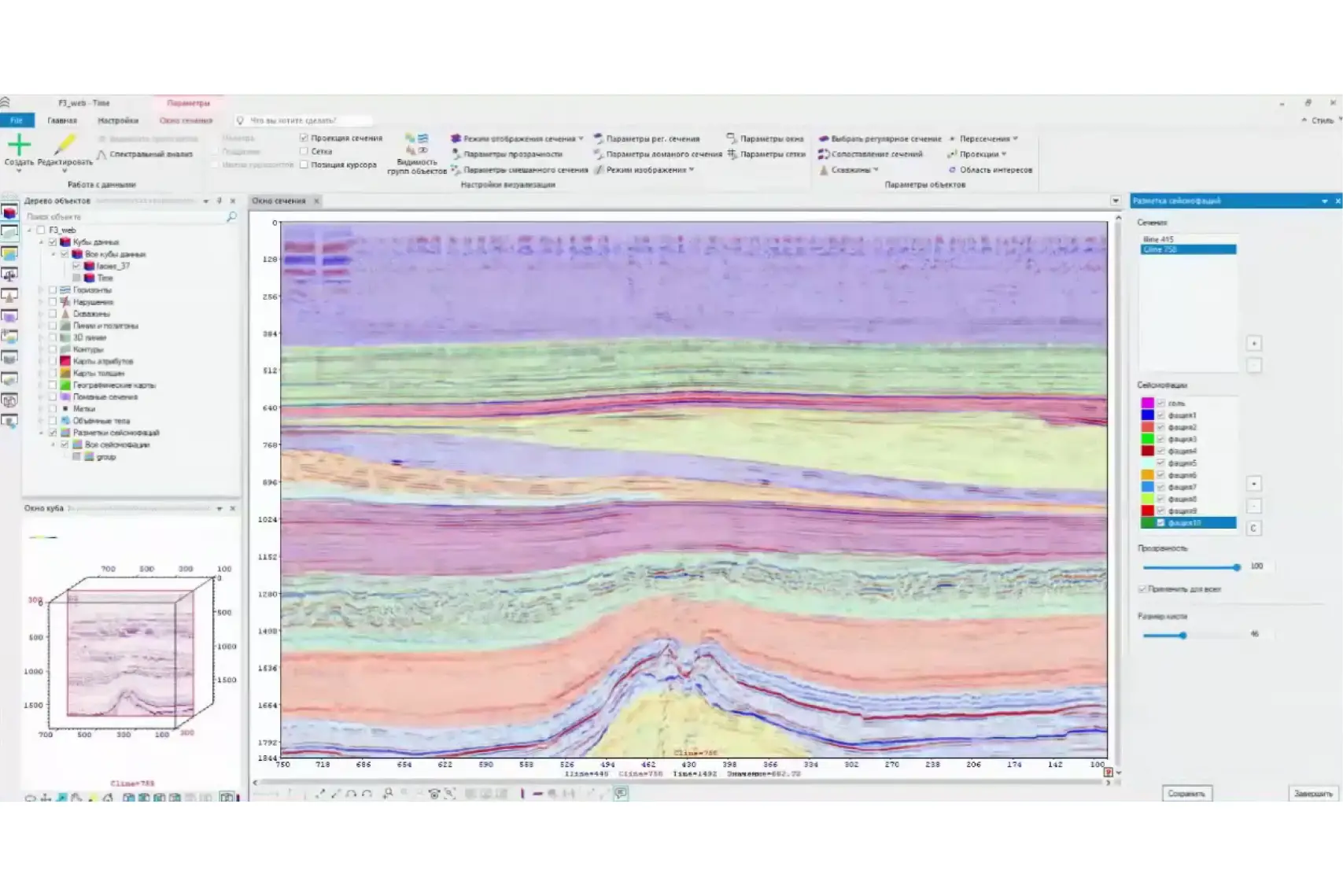
Step 3: Refine Labeling
Now the geophysicist makes manual adjustments: labeling desired areas with a brush, adjusting transparency, disabling or adding individual classes. It is important that the model considers not only individual patterns but also the geological context – the strike and structure of the complexes.
Step 4: Fine-tune the Model
Taking into account the corrections made, we initiate retraining. This takes about 30 minutes. The model “adapts” to the data of the specific cube. Validation on a test section shows that the result is close to expert markup, even where manual work was not performed.
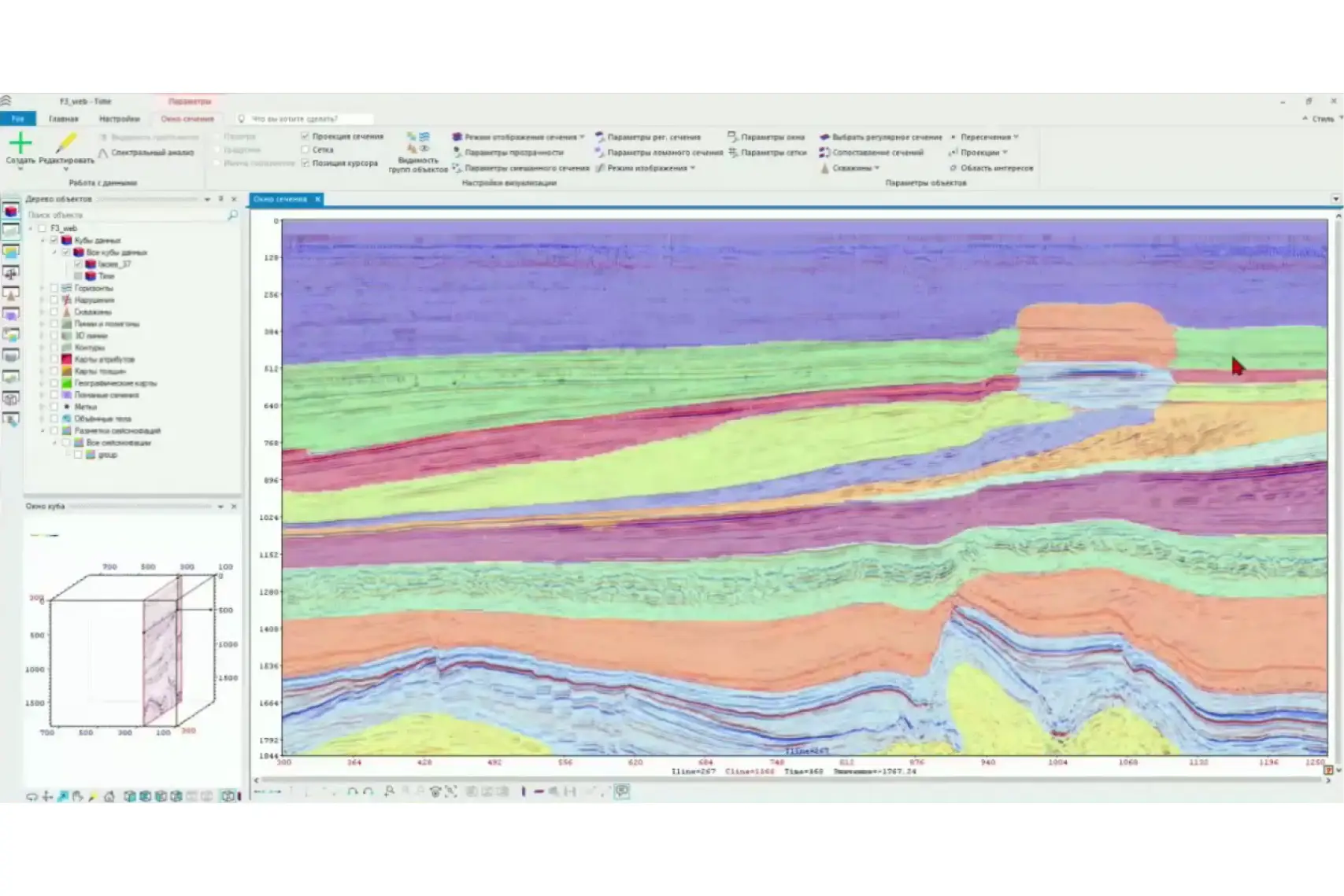
Step 5: Obtain the Structural Map
In the final step, we obtain a ready-made three-dimensional cube: it can be rotated, transparency can be changed, and it can be compared with the original seismic data. The model not only reproduces the labeling but also identifies an additional seismic feature that was not provided for training. Its nature requires verification, but the fact itself demonstrates the additional value of AI – it functions both as an interpretation tool and as a quality control measure.
Thus, a sequence of five steps—from loading the cube to a finished structural plan—allows you to obtain in hours a result that previously required weeks. Everything looks simple: the system is already trained on models and can “recognize” basic patterns. But a natural question arises: what exactly was it trained on, and can this data be trusted? We will discuss this further.
Synthetic Data Instead of Real Data – Can It Be Trusted?
To train an interpretation model, tens of thousands of seismic cubes are needed – but such arrays simply do not exist in nature. Such large and yet cleanly labeled datasets cannot be acquired or compiled.
This problem arose for the GridPoint Dynamics team several years ago. They were the first to create a synthetic seismic data generator. The solution proved challenging: they had to prove that artificial cubes were suitable for training. The proof came in the form of case studies – models trained on synthetic data worked confidently on real projects and yielded reproducible results.
Today, the question “can it be trusted” is rarely heard: the use of synthetic data has become standard, including among major companies.
The main advantage of this approach is that synthetic data allows modeling “clean” geological scenarios: different types of tectonics, noise, and distortions. Algorithms learn from reference examples where it is precisely known what is located where.
Then the expert gets involved. Several real sections are manually labeled, and the model is fine-tuned on the data of a specific project. This achieves a balance: the scalability of synthetic data is combined with the precision of a geophysicist’s live experience.
What if AI makes a mistake?
This is a common question: the machine can highlight something unnecessary or, conversely, miss something important. And this is precisely why the model always produces a result in the form of a “baseline” that the user sees.
Next, an expert steps in if they want to incorporate their vision and interpretation experience into the model. The geophysicist marks up several key sections, the model retrains, and rebuilds the cube. This is a fundamental point: the system is not closed and not a “black box”—every action remains transparent and verifiable.
And here, a specialist is indispensable. Only a geophysicist considers the tectonics, stratigraphy, and specific features of a particular field. Their knowledge and experience transform a machine’s sketch into a complete interpretation.
Essentially, AI does not replace the expert, but rather augments them: it removes routine burdens and allows them to focus on complex, analytical tasks where the final decision always rests with the human.
What if the data is poor – can AI handle it?
Perfect seismic data almost never exists. Especially when dealing with old surveys: noise, “footprints,” and low resolution obscure details. In such cases, special AI modules for cleaning and quality enhancement are employed. They are trained on synthetic data: the system is shown a noisy cube and its “clean” reference, and the algorithm learns to restore the original quality.
These modules allow for:
- removing random noise,
- smooth acquisition artifacts (“footprints”),
- correcting amplitudes,
- increasing resolution and image clarity.
Thanks to this, what was previously considered “junk” material becomes a working basis for interpretation again.
And this applies not only to 3D cubes. Algorithms also work with 2D lines – including archival ones. Even old formats can be brought to a state where they return to circulation as a valuable source of geological information.
How to Implement AI in Your Workflow
Yes, everything looks convincing. Now the main question is: how do you implement this in your company? Implementing AI software is not a one-time service, but rather a customization to the company’s processes. After purchasing the product, the vendor helps install the system, integrate it into the workflow, and trains specialists. Support and refinement of algorithms also remain with the vendor’s development team.
Training formats:
- webinars – open demonstrations of typical workflows;
- individual sessions – analysis of specific client projects;
- on-demand support – answers to questions and assistance with work.
Important: users do not need to know AI mathematics or understand neural network architecture. Geophysical expertise is sufficient – the ability to label data, verify results, and use the tool to accelerate routine steps.
Thus, implementation does not require a separate R&D department. It is enough to purchase the product, undergo training – and you can start working.

Where to Try AI in Practice
If you are not yet representing a company, but are studying or working and want to master modern seismic data interpretation tools, there are several ways to try them in practice.
For Students
A separate channel for implementation is student licenses. These are already used, for example, at Gubkin University, TPU, and KFU. This is a chance to get acquainted with AI tools before entering the industry, try them on educational and research tasks, and join a company already prepared.
For Specialists
AI interpretation software is an expensive product, and it is impossible to purchase it independently. If a company is not ready to invest in licenses, there are several alternatives:
- participation in open competitions and championships (for example, Nedra Exploration Cup), where temporary access to tools is usually provided;
- taking specialized courses. For example, Alexandra Volkova at TPU has a separate module on modern seismic processing algorithms. The courses are paid, but they allow practical experience with modern tools.
In other words, even if you do not have corporate access to AI software, there is still an opportunity to experience these technologies. There are enough options – from student licenses to championships and author’s courses. The main thing is the desire to learn and the readiness to try new things.
AI in Geophysics: From Experiment to Working Tool
AI in geological and geophysical data interpretation is no longer an experiment – it is already working in real projects. Its main advantages are clear to anyone who has dealt with seismic data arrays. AI allows for:
- faster horizon correlation;
- automatic fault identification;
- more accurate well tie-in;
- cleaning and improving survey quality.
What used to take months of manual work can now be done in hours. This not only accelerates project launches but also makes it possible to “revive” archival data that was previously considered outdated. And most importantly, it frees up time for real geology: analyzing structures, searching for new scenarios, and formulating hypotheses.
The prospects for AI in geophysics are excellent. Specialists can finally engage in geophysics itself, rather than drowning in routine and tedious tasks.
says Daniil Bogoedov
AI in geophysics is not a trend, but a working tool that is shaping the future of the industry. The question now is not “whether,” but “when exactly” you will start using it.
What tasks in geophysics do you think AI should be applied to first? Share your opinion in the comments.
The material was prepared with the support of the Russian Ministry of Education and Science within the framework of the Decade of Science and Technology.