Opens in a new tab
Geoscan presents the Geoscan 701 Video and 201 Video drones, capable of flying without GPS and conducting video monitoring

Drones Work Without Satellites: Geoscan Shows Equipment for 210 km Surveys

23.10.2026
Reading time: 2 min
0

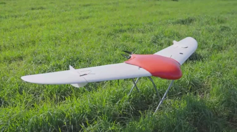
Losing GPS no longer puts a flight at risk. At DroneCongress in St. Petersburg, Geoscan presented two video monitoring systems: the Geoscan 701 Video and the Geoscan 201 Video. An onboard camera helps them navigate without satellites by comparing what it sees against a pre-loaded map.

Each system includes the aircraft itself, a ground communication station with a rotating antenna, and a camera with three-axis gyro stabilization. Video is transmitted over distances of up to 80 kilometers and recorded in 4K. The operator prepares routes, terrain, and map data in Geoscan Planner 3.0 software.

The senior model, the Geoscan 201 Video, gives the operator more freedom during the flight itself. Several streams can be viewed at once and switched between, and objects can be zoomed in on optically or in hybrid mode, up to two kilometers away. Automatic target tracking and manual FPV control are available. If conditions change, the route can be adjusted without interrupting the mission, and after the work is done the drone lands on its own.

In terms of endurance and range, the Geoscan 201 Video stays airborne for up to three hours and covers up to 210 kilometers. This makes it suitable for monitoring extended and hard-to-reach facilities, where it is important to see the picture over long distances and change the plan quickly.

The main advantage of the new products is their independence from satellite navigation. Where the signal is unstable or absent, the drone keeps working using the map and camera. For monitoring remote territories, this may prove a decisive argument.

Source: Geoscan
Image: Geoscan

Prepared by —
Author avatar
Yulia Frolova
Did you like this news? Share with friends
RELATED

Leave your comment


Editor-in-Chief
Maria Kostina
Maria Kostina
Geophysicist, founder of the project and editor-in-chief GeoConversation. Salt of the Earth
GO TO THE EDITOR'S COLUMN

GeoConversation. Salt of the Earth is a media platform where top mining-industry specialists share their experience, helping professionals communicate and collaborate more effectively.

Learn more about the project
TOP PROFESSIONALS
Марина Ельчанинова — эксперт по английскому, 13+ лет опыта. Tailor-made обучение, бизнес-тренинги, полное погружение в язык.

Marina Yelchaninova

English Dive In Online School
Head of Online School
Глеб Загорский

Gleb Zagorsky

State Scientific Center of the Russian Federation, Arctic and Antarctic Research Institute
Geophysics Engineer
Андрей Кармышев

Andrei Karamyshev

Karpinsky Institute
Category 1 Geophysicist
VIEW ALL EXPERTS
CATEGORIES
SUBSCRIBE
If you would like to receive a monthly selection of fresh articles by email
LIKE THE PROJECT? SUPPORT US
Friends, developing the project takes a lot of effort and financial resources. If you like what we do, you can support us in two ways.
MORAL SUPPORT
Show our website to your friends. Just click on the social media icons below and share our website on your pages.
FINANCIAL SUPPORT
Even a small fee will help us pay for the transcription (audio to text) of an expert interview or the design of drawings, diagrams, and tables.
Send a donation
Got an article idea? Suggest it.
Cool! You have an idea for us. We love that, because only the experience and knowledge of an expert makes our articles useful for the reader. Please answer 5 questions to let us know a little more about you and the article
answer questions