Beneath two to three kilometers of rock there may lie rich deposits of nickel and platinum-group metals, but surface methods cannot see them. Scientists from Voronezh State University and the Kola Science Centre of the Russian Academy of Sciences have proposed a way to look deeper, relying on rock density and data from thousands of boreholes.
The method is based on gravimetry. Every rock has its own density and therefore creates barely noticeable deviations in the Earth’s gravity field. An algorithm converts these deviations into a three-dimensional geological picture. The foundation is a digital database of measurements on samples from more than five thousand boreholes drilled in the region over decades.
The model is built in three steps. First, distortions from the sedimentary cover are removed. Then a regional model of the lithosphere down to 80 kilometers is assembled. Only after that do researchers move to a detailed 3D model of the upper crust down to 16 kilometers. The key feature is a normal density model of the lithosphere: it makes it possible to work with absolute values and to join the regional and detailed levels without gaps.
Sixteen kilometers does not mean mining from such depth. Mines today operate at horizons of up to two or three kilometers, and the Kola Superdeep Borehole barely passed twelve. The depth is needed for another purpose. Copper-nickel ores and platinum-group metals are born from magma rising from the mantle. The deposits themselves form not in the deep roots but in trap chambers at accessible levels. To find these traps, one must trace the path of the melt from below.
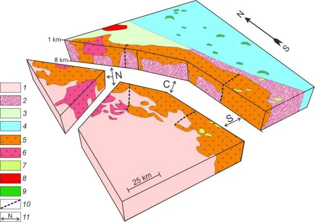
A test on the Voronezh Crystalline Massif showed how much surface maps diverge from the subsurface. The Pavlovsk batholith looks one way at the surface, but at depths of up to eight kilometers it turns out to be a single sill-like body with subvertical roots shifted to the east. Moreover, the Pavlovsk and neighboring Liski granitoids were found to share a common magmatic root zone.
Practical implementation of the method became possible thanks to GIS technologies, which ensure precise referencing of all calculations to real coordinates.
A 3D model in absolute densities makes it possible to trace large intrusions to depth and find their root parts. For the Voronezh massif, this is a chance to discover hidden extensions of known copper-nickel sites and platinum-group metal occurrences. The scientists have given subsoil users a navigator: drill not at random, but where the magmatic system has actually left an ore trap.
Source: Bulletin of the Tomsk Polytechnic University
Image: FRC KSC RAS website