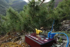
Geophysicists from Vitus Bering Kamchatka State University have adapted the georadar method to predict landslides and landslides in seismic zones of Kamchatka. The new approach makes it possible to study soil at a depth of up to 50 meters and identify potential threats.
KamSU scientists have developed a unique method that will help predict dangerous natural processes such as landslides, landslides and screes. This approach is especially relevant for Petropavlovsk-Kamchatsky, where a third of the territory is located in a zone of increased seismic activity.
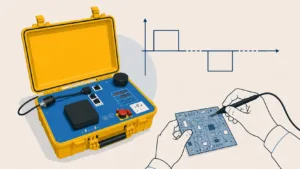
The method is based on the use of electromagnetic pulses that are sent into the ground and returned back, allowing a detailed picture of underground structures to be obtained. Experts can identify voids, faults and changes in the soil, which helps predict possible disasters.
One of the key objects of the study was Nikolskaya Sopka, a popular tourist destination. Scientists have discovered 15 active talus here, the largest of which reaches 65 meters in length and 24 meters in width. The analysis showed that the sizes of rock fragments vary from 1 to 24 centimeters.
In addition, 70% of the surface of the hill is covered with a network of cracks, most of which are a combination of longitudinal and transverse faults. This structure is especially dangerous, as it can lead to new collapses, especially during earthquakes.
A new ground penetrating radar method opens up opportunities for more accurate prediction of natural disasters in Kamchatka. This is an important step in ensuring the safety of residents and tourists in the region.
Source: izyskateli.info
Photo: MK