Scientists have created the first detailed map of the surface of Antarctica’s subglacial relief. The study revealed mountains, deep canyons and hills that were previously hidden beneath ice.
Antarctica hides a complex topography under a two-kilometer ice cover about which scientists knew very little. A new mapping project has revealed that beneath the ice crust are mountains, deep canyons and numerous hills, creating an unexpectedly diverse landscape.
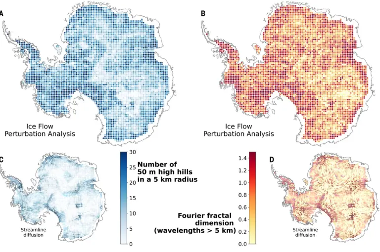
The researchers combined satellite images of the ice surface with measurements of the thickness of the ice layer. Using the Ice Flow Perturbation Analysis method, which analyzes the movement of ice taking into account the laws of physics, they were able build a map subglacial relief. Changes in the shape of ice as it moves make it possible to determine what is underneath it.
The new map showed 71,997 hills across the continent – twice as many as previous maps. Of particular interest is the deep valley, almost 400 kilometers long, in the Maude Basin. Some areas resemble alpine mountain landscapes with sharp peaks, rather than smooth hills, as previously thought. These features create more friction and slow the movement of ice towards the sea.
The resulting map not only reveals a hidden world beneath Antarctica, but also helps climate scientists more accurately predict melting glaciers and rising sea levels. More detailed maps will help improve models and understand how ice cover affects global warming.
Discoveries show that Antarctica is under ice cover much more complex than thought. The new data will help scientists more accurately assess the future of glaciers and the continent’s influence on the Earth’s climate.
Source: Phys.org
Image: Science