European radar satellites have recorded significant ground deformation following two powerful earthquakes in the Caribbean region. The magnitude 7.2 and 7.5 earthquakes displaced the Earth’s surface near Caracas by as much as 30 centimeters. The satellite data has already been shared with emergency response agencies.
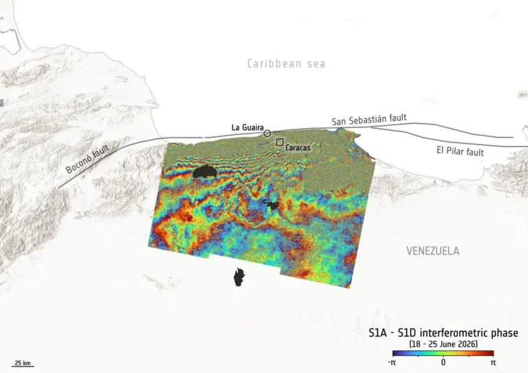
The European Space Agency (ESA) has released an interferogram—a specialized map of ground deformation generated from imagery collected by Sentinel-1 satellites under the Copernicus Earth observation program. Unlike conventional optical satellites, Sentinel-1 uses radar to transmit microwave pulses toward the Earth’s surface and measure the return signal. By comparing images of the same area acquired on different dates, scientists can detect ground movements with centimeter-level accuracy, even when no visible changes appear on the surface.
The analysis used two radar images: one acquired on June 18, approximately one week before the earthquakes, and another collected on June 25, one day after the seismic events. The resulting interferogram reveals distinctive concentric color bands north of Caracas. Each complete color cycle—from blue through green and yellow to red and back again—represents another increment of change in the distance between the satellite and the Earth’s surface. The greater the number of color fringes, the larger the overall displacement.
According to ESA’s analysis, ground deformation reached approximately 30 centimeters in the area closest to the epicenter. The deformation coincides with the San Sebastián Fault, one of northern Venezuela’s principal tectonic structures.
An important limitation of radar interferometry is that it measures only the total displacement relative to the satellite’s orbit. It cannot independently distinguish between vertical uplift, subsidence, and horizontal movement. During major earthquakes, the Earth’s crust often experiences all three simultaneously. Additional ground-based geodetic surveys and complementary observation techniques will be required to fully characterize the deformation.
While scientists continue processing satellite observations, search-and-rescue operations remain underway in the affected areas. International space agencies and disaster-monitoring centers have coordinated their resources to support emergency responders. NASA, for example, has activated its Disaster Response Coordination System, which identifies high-risk zones and helps coordinate emergency operations.
Radar satellites have become an indispensable tool for assessing earthquake impacts. They provide emergency responders and authorities with rapid, high-precision information on where and by how much the ground has shifted—often well before field teams can reach the affected locations.
Source: European Space Agency (ESA)
Image: Copernicus Sentinel / ESA